
Interview: Krešimir Kuk on Earthquake Risks and Seismic Preparedness
Interviewer: Atty. Bilge Kaan ÖZKAN
Guest: Krešimir Kuk – Department of Geopyshics

1.
B.K.Ö:: Mr. Kuk, thank you for joining us. Could you briefly introduce yourself and your background in seismology?
Krešimir Kuk: Thank you for having me. I am a seismologist with over 20 years of experience in earthquake research and risk management. My work focuses on monitoring seismic activity, analyzing fault lines, and advising on disaster preparedness strategies both in Croatia and internationally.
2.
B.K.Ö:: How would you describe the earthquake risk in Hırvatistan compared to Türkiye?
K.K.: Both countries are seismically active but in different ways. Turkey sits on multiple major fault lines, including the North Anatolian Fault, making it prone to large magnitude earthquakes. Croatia, on the other hand, has moderate activity concentrated in regions like Zagreb and along the Dalmatian coast, with smaller but still significant seismic events.
3.
B.K.Ö:: Are there particular regions in Hırvatistan where earthquakes are more likely?
K.K.: Exactly, yes. Zagreb, the capital, sits near active fault lines and has experienced damaging earthquakes in the past, most notably the 2020 Petrinja earthquake. Coastal areas, especially Split and the Dalmatian islands, also experience occasional seismic activity due to the Adriatic tectonics.
4.
B.K.Ö:: Can we expect earthquakes of similar magnitude in Croatia as those in Türkiye?
K.K.: Major earthquakes in Croatia tend to be smaller than the largest ones in Türkiye, but they can still cause significant damage locally, particularly in older or unreinforced buildings. So while magnitudes may differ, the risk should not be underestimated.
5.
B.K.Ö:: How accurate are earthquake predictions, scientifically speaking?
K.K.: Predicting the exact time and magnitude of earthquakes is currently impossible. We can identify high-risk zones and the likelihood of future activity based on historical and geological data, but precise forecasts remain beyond our capabilities.
6.
B.K.Ö:: What lessons can Hırvatistan learn from Türkiye’s experience with earthquakes?
K.K.: Turkey has a long history of dealing with high seismic risk. One key lesson is the importance of strict building codes and retrofitting older structures. Another is public education on emergency preparedness, which significantly reduces casualties during major events.
7.
B.K.Ö:: How do modern monitoring systems improve earthquake preparedness?
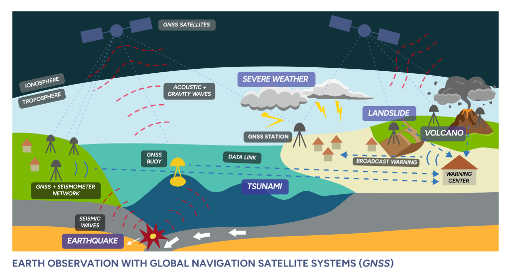
K.K.: Seismic networks, GNSS sensors, and early warning systems allow us to detect tremors quickly and alert populations before the strongest shaking reaches them. This can save lives and protect critical infrastructure.
8.
B.K.Ö:: Have you observed any recent changes in seismic activity in the Adriatic region?
K.K.: There has been a slight increase in minor tremors in some areas, such as near Zadar and Berkovići. These events highlight the continuous activity along local faults, though they are mostly small and do not pose widespread danger.
9.
B.K.Ö:: How can cities like Zagreb prepare for future earthquakes?
K.K.: Urban planning must prioritize seismic resilience: retrofitting old buildings, enforcing modern construction standards, and designing evacuation routes.
Public drills and awareness campaigns are also crucial for community readiness.
10.
B.K.Ö:: What role does research play in mitigating earthquake damage?
K.K.: Research informs building codes, emergency protocols, and hazard maps. By understanding fault behavior and ground motion, we can better anticipate the impact of earthquakes and reduce risks to populations.
11.
B.K.Ö:: Are there technologies or innovations you see as game-changers for earthquake safety?
K.K.: Early warning systems and real-time monitoring via GNSS and IoT sensors are transformative. They can automatically shut down critical systems, alert emergency services, and provide seconds to minutes of warning before the main shock.
12.
B.K.Ö:: How do earthquakes affect local economies, even if the magnitude is moderate?
K.K.: Even moderate quakes can damage infrastructure, homes, and historic buildings. The economic cost includes repair, disruption to business, and long-term recovery. That’s why investing in prevention is far cheaper than post-disaster response.
13.
B.K.Ö:: What is the public perception of earthquake risk in Croatia?
K.K.: Many people underestimate the risk, especially in regions without recent major events. Raising awareness through education campaigns and regular drills is essential to foster a culture of preparedness.
14.
B.K.Ö:: What advice would you give to residents in earthquake-prone areas?
K.K.: Be proactive: secure furniture, know safe spots in your home, and have an emergency kit ready. Understand evacuation plans and participate in local drills. Knowledge and preparation can save lives.
15.
B.K.Ö:: Finally, what is your outlook for seismic activity in the next decade in both Türkiye and Croatia?
K.K.: Turkey will continue to face significant earthquake risk due to its major fault lines, so continuous vigilance is required. Croatia will likely experience smaller but still impactful events. Both countries must prioritize preparedness, infrastructure resilience, and public education to reduce risks.
16.
B.K.Ö: Many experts have been discussing the expected major earthquake in Istanbul along the North Anatolian Fault. From your perspective, what are the potential risks and necessary preparations?
K.K.: Istanbul is in a very high-risk zone due to the North Anatolian Fault. A major earthquake could affect millions of people, and older buildings are particularly vulnerable. Preparation should focus on retrofitting structures, strengthening emergency response systems, and educating the public. Early warning systems and community drills are also essential to reduce casualties and damage.
17.
Mr. Kuk, could you tell us which regions in the world are more likely to experience significant earthquakes in the near future?
KK: Earthquakes are most likely in areas located on active tectonic plate boundaries. For example, the Pacific “Ring of Fire” — stretching from Japan, Indonesia, Chile, Mexico, to the west coast of the United States — is one of the most seismically active regions. Large earthquakes are expected there simply because of the constant interaction between plates.
Q: And what about Europe, including Croatia?
KK:: In Europe, the Mediterranean region is most active. Turkey, Greece, Italy, and the Balkans all lie on complex fault systems where the African and Eurasian plates interact. For Croatia specifically, moderate earthquakes are always possible, particularly around Zagreb and the Adriatic coastal areas.
Q: People often ask if scientists can predict exactly when and where a major earthquake will occur. What is your response?
KK: Unfortunately, exact prediction is not possible with current science. What we can do is assess probabilities based on historical data, geology, and seismic monitoring. That’s why preparedness, resilient infrastructure, and public awareness are far more important than trying to guess the exact date of an earthquake.
Interview: The Future of GNSS Solutions and Its Impact on Industry
Interviewer: Atty. Bilge Kaan Özkan
Guest: Stéphanie Gosselin, Sales Consultant at Effigis
1.
Bilge Kaan Özkan: Ms. Gosselin, thank you for joining us. To begin, how would you define GNSS Solutions in the simplest terms?
Stéphanie Gosselin: Thank you for having me. GNSS Solutions is essentially a “positioning data processing software.” It takes raw data collected from GNSS satellites, processes it using mathematical and geodetic models, and delivers highly accurate coordinates to the user. In other words, it allows you to determine the position of a point in the field with centimeter-level accuracy. But it’s more than just a tool—it is a platform for positioning validation and analysis.
2.
B.K.Ö.: Who exactly is the target audience for GNSS Solutions? Is it exclusively for professional surveyors, or does it cater to a broader community?
S.G.: At first glance, it may seem like surveyors, geomatics engineers, and researchers are the primary users. But in reality, it serves a much wider community. Precision farmers, engineers in construction, archaeologists requiring accurate site mapping, and even energy companies rely on it. So, GNSS Solutions is not just an academic or technical product—it’s a multi-sector solution package.
3.
B.K.Ö.: What kind of feedback does Effigis receive from clients using this software in the field? Which features do they value most?
S.G.: The feedback we hear most often is about reliability and flexibility. Users typically work in challenging environments: dense urban areas, mountainous regions, or forests. GNSS Solutions, with its multi-constellation support, still manages to deliver. Clients also appreciate its user-friendly interface, which allows even non-engineers to get up to speed quickly. For us, the most rewarding feedback is that the software helps users save time and streamline their workflows.
4.
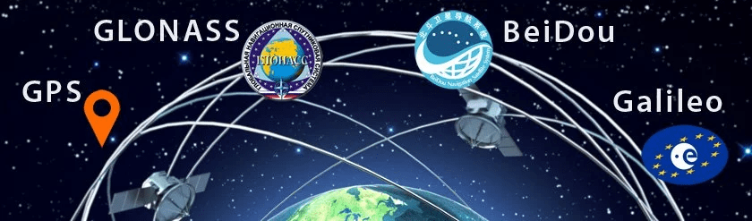
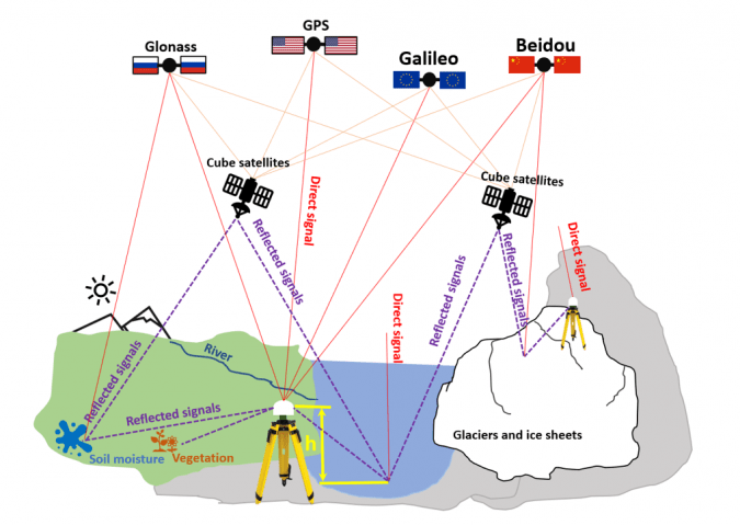
B.K.Ö.: GNSS Solutions supports multiple satellite constellations such as GPS, GLONASS, Galileo, and BeiDou. How does multi-constellation use benefit field operations?
S.G.: Multi-constellation is essentially the guarantee of accuracy and continuity. Relying on a single system can be risky. For example, in urban canyons where GPS signals may reflect off buildings, Galileo or BeiDou signals can compensate. This reduces errors and ensures uninterrupted measurement capability.
5.
B.K.Ö.: The software can process both static and kinematic data. Could you explain this difference with practical examples?
S.G.: Of course. Static processing is typically used for long-term measurements, such as establishing geodetic networks or monitoring tectonic movements. Kinematic processing, on the other hand, is ideal for dynamic surveys. For example, during a drone flight, GNSS Solutions can calculate positions in real time, enabling the production of high-resolution maps. In short: static data ensures long-term accuracy, while kinematic data delivers real-time precision.
6.
B.K.Ö.: Positioning technologies are now used everywhere, from autonomous vehicles to agriculture. In your view, which industry benefits the most from GNSS Solutions today?
S.G.: It’s hard to single out just one, but agriculture and logistics are making remarkable progress. In agriculture, centimeter-level positioning prevents seed waste, optimizes fertilizer and pesticide use, and reduces costs. In logistics, GNSS Solutions helps validate fleet routes more efficiently, lowering fuel consumption and carbon emissions. So the benefits are not just economic, but also environmental.
7.
B.K.Ö.: In developing countries like Türkiye, where do you see GNSS solutions spreading most rapidly?
S.G.: Three sectors come to mind: infrastructure, agriculture, and energy. Türkiye’s geographical diversity makes accurate positioning critical. For example, in dam construction or highway projects, GNSS Solutions can form the backbone of the work. In agriculture, given Türkiye’s vast farmlands, I expect precision farming technologies to expand quickly.
8.
B.K.Ö.: What is Effigis’ vision in the GNSS field? What innovations can we expect to see in GNSS Solutions in the coming years?
S.G.: Our vision is to make GNSS data more accessible, faster, and more integrated. In the coming years, you will see more cloud-based versions of GNSS Solutions. This will allow users to process data directly from the field without having to return to the office. We are also working on AI-powered error analysis, which will guide users toward more accurate results in less time.
9.
B.K.Ö.: For those who want to learn GNSS Solutions, how do training and support systems work?
S.G.: At Effigis, we offer a comprehensive training ecosystem. There are online courses, video tutorials, and interactive workshops. We also provide on-site training when needed. On the support side, we run a 24/7 technical assistance line. So even if a user in Türkiye encounters a challenge in the middle of the night, they can count on us for immediate help.
10.
B.K.Ö.: Finally, what advice would you give to professionals who are new to GNSS Solutions or considering adopting it?
S.G.: My biggest advice would be: don’t look at GNSS Solutions as just “software.” Think of it as a platform that transforms your workflows. It doesn’t just validate coordinates; it accelerates decision-making processes. At first, it may seem complex, but once you understand the basics, you’ll see how much it simplifies your work. My recommendation for beginners is to start with small projects and gradually move on to more complex ones. This way, they can unlock the full potential step by step.
11.
B.K.Ö.: Recently, climate change and environmental sustainability have become global priorities. How can GNSS Solutions contribute to tackling these challenges?
S.G.: That’s a very important question. GNSS Solutions plays a direct role in sustainability. For example, in precision agriculture, farmers can reduce overuse of fertilizers and pesticides by applying them only where they are needed. In forestry, GNSS helps monitor deforestation and land degradation. In urban planning, it supports smarter infrastructure that minimizes environmental footprints. So, positioning accuracy translates directly into more responsible use of natural resources.
12.
B.K.Ö.: Autonomous vehicles are making headlines almost every week. Where does GNSS Solutions fit into this technological race?
S.G.: GNSS is one of the backbones of autonomous mobility. While sensors like LiDAR and cameras are crucial, they don’t work well in every condition—for example in fog or heavy snow. GNSS, on the other hand, provides reliable positioning regardless of visibility. GNSS Solutions ensures that autonomous vehicles can localize themselves with centimeter-level accuracy. This is critical for safety, traffic efficiency, and even insurance compliance in the future.
13.
B.K.Ö.: Security and data integrity are hot topics, especially with concerns over cyber threats. How does Effigis address these risks in GNSS Solutions?
S.G.: GNSS signals can indeed be vulnerable to spoofing or jamming. At Effigis, we take this very seriously. GNSS Solutions integrates advanced algorithms to detect anomalies in satellite data, helping users identify potential interference. We are also working on partnerships to integrate encrypted GNSS services, like Galileo’s Public Regulated Service (PRS). In other words, security is now part of accuracy.
14.
B.K.Ö.: With the rollout of 5G and the Internet of Things, location-based services are exploding. Do you see GNSS Solutions playing a role in this ecosystem?
S.G.: Absolutely. 5G enables ultra-low latency communication, and GNSS provides the precise positioning backbone. Together, they power next-generation applications: smart cities, connected logistics, drone delivery, and real-time asset tracking. GNSS Solutions ensures that the positioning side of this equation is reliable, which is fundamental for IoT scalability.
Interview: Prof. Dr. Götz Bokelmann on the Imminent Istanbul Earthquake
Interviewer: Atty. Bilge Kaan OZKAN
Guest: Prof. Dr. Götz Bokelmann, University of Vienna, Department of Geophysics
First Question:
Dear Professor; Turkey frequently experiences earthquakes, and Istanbul is often described as a ticking time bomb. How do you assess the situation scientifically?
Answer:
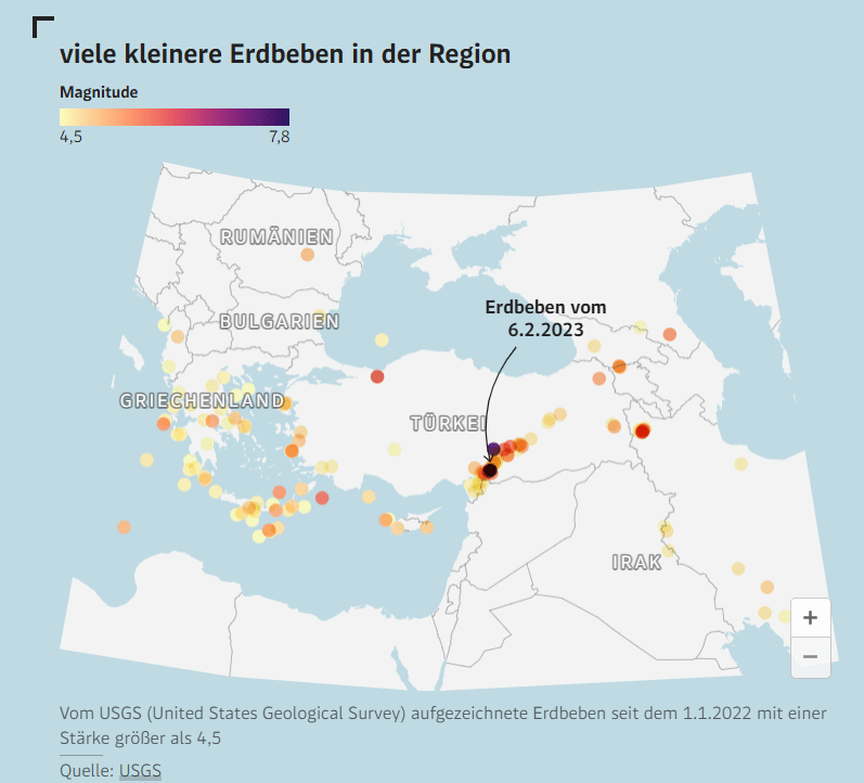
The scientific community is in broad consensus: the North Anatolian Fault is overdue for a major rupture beneath the Sea of Marmara. The question is not if but when. This accumulated stress does not simply vanish; it must eventually be released. Istanbul, with its dense population and vulnerable infrastructure, stands at the epicenter of a predictable disaster. Most of the recent earthquakes have occurred on the northern edge of the Anatolian Plate, the 1,500-kilometer-long North Anatolian Fault: “A major earthquake is feared there too, and it could affect Istanbul and the surrounding area.”
Second Question:
Is there any reliable timeframe for this expected earthquake?
Answer:
We cannot predict earthquakes to the day or year. But history offers a warning: the last major rupture on this fault occurred in 1766. Statistically, Istanbul is well beyond the average recurrence interval. When I say there is a 60% chance within 30 years, people often think, “That sounds far away.” But scientifically, it means the city is already living on borrowed time.
Third Question:
Which districts of Istanbul would be most severely affected?
Answer:
The impact will not be uniform. Low-lying coastal districts with weak soil—Avcılar, Zeytinburnu, parts of Fatih—are particularly fragile. On the Asian side, Kadıköy and Maltepe’s shoreline is at risk. However, I want to stress: even areas with solid ground can collapse if construction quality is poor. The built environment is as decisive as geology.
Forth Question:
In your view, is Istanbul’s current building stock prepared?
Answer:
Frankly, no. The 1999 earthquake should have been a turning point. New regulations were introduced, but enforcement was inconsistent. Thousands of buildings still stand that would not withstand strong shaking. It is not an issue of knowledge—we know what needs to be done. It is an issue of political will and societal priorities. Too often, short-term economic interests overshadow long-term safety.
Fifth Question:
How would you evaluate Turkey’s disaster management strategy?
Answer:
Turkey has impressive capacity for rapid response once disaster strikes, but prevention is the weak link. Earthquake preparedness is more than rescue operations; it is about reducing risk before tragedy occurs. I often compare it to medicine: would you prefer intensive care after a heart attack, or preventive care to avoid the heart attack altogether? The latter saves more lives and costs less.
Sixth Question:
What would be the broader consequences of an Istanbul earthquake?
Answer:
Istanbul is not only Turkey’s cultural heart but also its economic engine. A catastrophic earthquake would reverberate globally—through disrupted trade routes, financial markets, and energy corridors. This is why international cooperation matters: Istanbul’s safety is not only a national concern but a regional and global one.
Seventh Question:
Is there any hope of predicting earthquakes more precisely in the near future?
Answer:
Prediction in the strict sense remains impossible. But monitoring technologies are improving: satellite geodesy, GPS deformation networks, and ocean-bottom seismometers give us unprecedented insight. These do not prevent earthquakes, but they allow for risk maps, early-warning systems, and better-informed urban planning. The tragedy is that we often fail to act on the information we already have.
Eighth Question:
If you were in charge of Istanbul’s earthquake policy, what immediate steps would you take?
Answer:
Three priorities:
- Aggressive urban renewal—unsafe buildings must be demolished now, not after the disaster.
- Public spaces—secure and expand gathering areas instead of allowing them to be turned into commercial projects.
- Public education—turn earthquake drills into a culture, not a rare event. Prepared citizens are as vital as strong buildings.
Ninth Question:
Do you see enough collaboration between Turkish and international scientists?
Answer:
The collaboration is improving, but it is still too fragmented. The Marmara region is one of the world’s best natural laboratories for seismology. International teams are eager to cooperate, but data sharing is sometimes restricted by bureaucracy or politics. Science thrives on openness. Transparency here is not only academic courtesy—it could literally save lives.
Tenth and the Last Question:
Finally, what message would you like to give to Istanbul’s citizens?
Answer:
Istanbul is a magnificent city, but it is also fragile. The earthquake cannot be stopped, but the tragedy can be minimized. My message is simple: demand accountability, insist on safe housing, and treat earthquake preparedness as a daily responsibility, not a distant possibility. The real danger is not the earthquake itself—it is complacency.
