
In-Depth Interview with Stefano Bertone – Advanced Planetary Science, Astrometry, and Space Exploration
Interviewer: Atty. Bilge Kaan ÖZKAN
Guest: Dr. Stefano Bertone – Planetary Science Division, NASA Goddard Space Flight Center, Greenbelt, MD, USA
1. BKÖ: Mr. Bertone, when people hear “NASA scientist,” they imagine rockets and astronauts—but what does a normal working day actually look like for you?
Mr. Bertone: That perception is very understandable, because the most visible aspect of space exploration is indeed launches and human missions. However, for those of us working in planetary science and astrometry, a typical day is centered much more on data analysis, modeling, and interpretation than on anything directly related to rockets.
A significant part of my day involves working with datasets produced by space missions. These include radiometric tracking data, such as Doppler and range measurements, laser altimetry data that provide precise surface elevations, and high-resolution imagery. Before any scientific conclusions can be drawn, these datasets must be carefully processed. This includes calibration, noise reduction, time alignment, and corrections for physical effects such as relativistic signal propagation and environmental disturbances.
Once the data are properly prepared, we develop mathematical models to interpret them. For instance, we analyze how a spacecraft’s orbit deviates from an ideal trajectory in order to infer the gravitational field of a planetary body. This involves solving complex inverse problems and using numerical methods that often require high-performance computing resources.
Another important part of the work is validation. We compare results obtained from different instruments and independent datasets to ensure consistency. If discrepancies arise, they must be investigated thoroughly, as they may indicate either measurement errors or new physical phenomena. Collaboration is also essential—we regularly work with engineers, physicists, and mission planners to refine models and improve accuracy.
In summary, while the work may not involve standing near a launchpad, it plays a critical role in enabling those missions. The accuracy of our models directly affects spacecraft navigation, landing safety, and the scientific value of the mission.
2. BKÖ: One thing people often wonder is this: how can you trust data coming from millions of kilometers away?
Mr. Bertone: This is a fundamental question, and in practice, we do not simply “trust” the data—we validate it continuously. The reliability of space data is established through a combination of calibration, redundancy, and statistical analysis.
Before launch, every instrument is carefully calibrated under controlled conditions. We determine its sensitivity, its noise characteristics, and any systematic biases it may have. These calibration parameters are then incorporated into the data processing pipeline.
Once the spacecraft is in operation, we continuously monitor the data it produces. We compare observations with predictions based on physical models. For example, we know how a spacecraft should move under the influence of gravity. If the observed motion differs from the prediction, we analyze whether the difference is due to a real physical effect or a measurement artifact.
We also rely heavily on redundancy. Different instruments often measure related quantities in independent ways. For example, gravity field estimates derived from spacecraft tracking can be compared with surface topography obtained from laser altimetry. Consistency between these datasets increases confidence in the results.
Finally, every measurement is associated with an uncertainty estimate. Rather than treating data as exact, we quantify how reliable it is. This allows us to assess the robustness of our conclusions and to identify areas where improvements are needed.
3. BKÖ: How precise are your measurements really? Are we talking meters, centimeters, or even smaller?
Mr. Bertone: The level of precision we achieve can be extremely high, often beyond what people might expect. For example, using radiometric tracking techniques, we can detect changes in a spacecraft’s velocity on the order of micrometers per second. This level of sensitivity is essential for identifying small gravitational perturbations.
In terms of position, spacecraft orbits around planetary bodies can often be determined with meter-level accuracy, even at very large distances from Earth. Laser altimetry measurements can achieve vertical accuracies ranging from a few centimeters to a few meters, depending on the instrument and mission design.
However, achieving this level of precision requires accounting for many different factors. Signals traveling between Earth and a spacecraft are affected by relativistic effects, solar plasma, and instrumental noise. Even small timing errors can introduce significant uncertainties if not properly modeled.
Therefore, precision is not only a property of the instruments themselves but also of the models we use to interpret the data. Without detailed physical modeling, the raw measurements would not reach their full potential.
4. BKÖ: If something goes wrong in your calculations, what kind of consequences could that have in a real mission?
Mr. Bertone: Even small errors in calculations can have significant consequences in space missions because of the precision required. A minor error in velocity estimation, for example, can accumulate over time and lead to large deviations in position.
During critical phases such as orbital insertion, an incorrect estimate could result in the spacecraft missing the intended orbit. In landing scenarios, inaccuracies in gravity models or surface topography could affect descent trajectories, increasing the risk of mission failure.
To mitigate these risks, we use multiple layers of validation, redundancy, and simulation. We test models under a wide range of conditions and analyze how uncertainties propagate through the system. This approach allows us to design robust solutions that can tolerate small errors without compromising mission safety.
5. BKÖ: People often hear about “gravity anomalies.” Does that mean there are places where gravity behaves strangely?
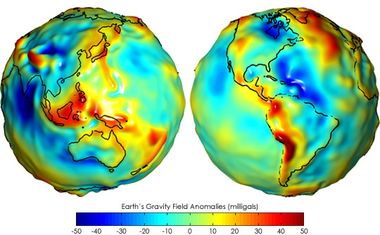
Mr. Bertone: Gravity anomalies do not mean that gravity behaves unpredictably, but rather that it reflects variations in mass distribution within a planetary body. Real planets are not uniform; they contain regions of different density, which produce measurable variations in gravitational attraction.
By observing how a spacecraft’s trajectory changes as it passes over these regions, we can detect and map these anomalies. This provides valuable information about subsurface structures that cannot be observed directly.
In this sense, gravity anomalies are not irregularities in the laws of physics, but rather indicators of the internal complexity of planetary bodies.
6. BKÖ: How do you decide where a spacecraft should land on another planet or the Moon?
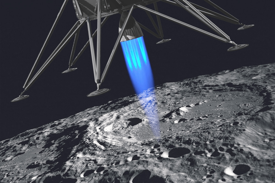
Mr. Bertone: Landing site selection is a complex process that involves balancing scientific goals with engineering constraints. We use high-resolution topographic data to evaluate surface slopes, roughness, and potential hazards such as craters or boulders.
Gravity models are also important, as they influence the spacecraft’s descent trajectory. Additionally, we consider environmental factors such as lighting conditions, temperature, and communication visibility.
The final decision is based on extensive simulations and analyses conducted by interdisciplinary teams, ensuring both safety and scientific value.
7. BKÖ: What makes a planet or moon “dangerous” for a spacecraft?
Mr. Bertone: Several factors can make a planetary body challenging or “dangerous” for spacecraft operations. One of the most critical is the gravitational environment. Unlike a perfectly uniform sphere, most planetary bodies have irregular mass distributions. These irregularities can perturb spacecraft orbits, especially at low altitudes, making precise navigation more difficult.
Surface conditions also play a major role. Rough terrain, steep slopes, and the presence of large الصخور or craters can create hazards for landing. Even small surface features can pose significant risks if they are not properly characterized.
Additionally, environmental conditions such as extreme temperatures, radiation levels, and dust can affect spacecraft systems. For example, fine dust particles can interfere with instruments and mechanical components, while radiation can degrade electronics over time.
All these factors must be carefully modeled and accounted for during mission planning to ensure safe and reliable operations.
8. BKÖ: Why do space missions take so many years before they even launch?
Mr. Bertone: Space missions require long preparation times because of their complexity and the need for reliability. Every component must be designed, tested, and validated under conditions that simulate the space environment.
Scientific instruments must be carefully calibrated, and mission objectives must be clearly defined. In addition, spacecraft systems must be integrated and tested as a whole, which is a highly iterative process.
Trajectory design also plays a role. Launch windows depend on planetary alignment, which may only occur at specific times. All these factors contribute to the extended timelines.
9. BKÖ: How do you deal with uncertainty in your measurements?
Mr. Bertone: Uncertainty is an intrinsic aspect of any space-based measurement. We quantify it rigorously rather than attempting to “eliminate” it, because all observational data carry instrumental, environmental, and model-based errors.
For instance, when tracking a spacecraft’s orbit, uncertainties arise from several sources: timing jitter in Doppler measurements, phase noise in radio signals, ephemeris errors in planetary positions, and unmodeled thermal forces acting on the spacecraft. Each of these contributions is propagated through our computational models using covariance analysis and Monte Carlo simulations.
We also perform sensitivity studies to determine how variations in specific parameters affect mission-critical outputs, such as landing precision or gravitational field estimates. By integrating uncertainties into our numerical simulations, we can provide probabilistic confidence intervals for every derived quantity, allowing engineers and mission planners to design robust operational strategies that account for potential deviations.
10. BKÖ: What is the biggest challenge in exploring another planet?

Mr. Bertone: One of the greatest challenges is integrating multi-scale, multi-physics models in a planetary environment fundamentally different from Earth. Spacecraft operate under extreme thermal gradients, variable radiation environments, and highly irregular gravitational fields. Each of these factors can interact in non-linear ways that are difficult to predict.
For example, modeling a low-altitude orbit around a small, irregularly shaped moon requires simultaneously accounting for non-uniform gravity, solar radiation pressure, and tidal perturbations. Small miscalculations in these areas can significantly affect orbital stability. Additionally, we must translate sparse or indirect remote sensing data into actionable engineering constraints, which requires high-fidelity inversion techniques and numerical optimization.
The interplay of autonomous spacecraft systems, delayed communications, and uncertain environmental parameters makes planetary exploration a complex problem of both engineering and applied physics.
11. BKÖ: How do you test your models without actually going there?
Mr. Bertone: We rely on high-fidelity simulations, laboratory analogs, and historical mission datasets. For example, numerical models of a Martian landing site can be validated against topographic and gravity data from orbiters, while regolith interaction can be tested using terrestrial simulants under controlled vacuum and temperature conditions.
We also employ data assimilation techniques to fuse observations from multiple instruments, ensuring internal consistency and cross-validation. By running thousands of Monte Carlo scenarios, we can stress-test our models against extreme or unlikely events, giving confidence that the models will remain robust under real mission conditions.
12. BKÖ: Why is international collaboration so important in space science?
Mr. Bertone: Planetary exploration is inherently multidisciplinary and resource-intensive. No single institution can maintain the full range of expertise, instrumentation, and funding required for a modern mission.
Collaboration allows the sharing of high-resolution datasets, laboratory calibrations, advanced computational models, and unique spacecraft platforms. For instance, gravity field data collected by a NASA orbiter can be combined with imaging from ESA missions and geophysical experiments from JAXA landers to produce comprehensive planetary models that would otherwise be impossible.
Additionally, joint development accelerates innovation, mitigates risk, and ensures that discoveries benefit the global scientific community, rather than being siloed within a single organization.
13. BKÖ: How does your work support future human missions?
Mr. Bertone: Our models provide precise environmental characterization critical for human exploration. This includes gravity mapping to determine stable orbital paths, topography and slope analyses for safe landing site selection, and hazard identification such as boulder fields or dust storms.
By simulating spacecraft-environment interactions under probabilistic scenarios—including solar radiation pressure, regolith dust transport, and thermal cycling—we help define operational constraints for human missions. This information feeds directly into trajectory planning, autonomous navigation algorithms, and mission risk assessments, effectively reducing uncertainty for crewed operations.
14. BKÖ: What excites you most about the future of space exploration?
Mr. Bertone: The combination of unprecedented measurement precision and computational power is transforming our ability to explore and understand planetary systems. We are now capable of resolving gravitational anomalies on small moons, detecting centimeter-scale topographic variations from orbit, and modeling complex multi-body interactions with high fidelity.
Looking forward, I am particularly excited about missions that integrate in-situ and remote sensing data in real-time, enabling adaptive exploration strategies. The convergence of AI-driven autonomous navigation, advanced instrumentation, and predictive planetary modeling opens the door to missions that can operate safely in environments we have never directly observed before. This era will allow us not just to observe other worlds but to interact with them in ways previously thought impossible.
15. BKÖ: If you were given the opportunity to travel to space and set foot on a planet or moon you’ve been studying, what would you be most eager to see and why?
Mr. Bertone: That is a profoundly exciting hypothetical because it allows me to connect the abstract, numerical world of planetary science with the visceral, tangible experience of exploration. From a scientific perspective, the first thing I would be most eager to examine directly would be the surface heterogeneities and geophysical anomalies that our remote sensing data have indicated but which we can only infer indirectly from orbit. For example, variations in surface composition, subtle undulations in topography, or evidence of past tectonic or volcanic activity are precisely the features that can transform theoretical models into concrete understanding. Being there in person would allow direct sampling and high-resolution contextual observation, enabling us to validate decades of orbital measurements and refine gravity and thermal models with unprecedented precision.
I would also want to investigate the interaction between the planetary surface and its surrounding environment. For instance, observing regolith behavior under low gravity, examining dust transport during diurnal cycles, or measuring local electromagnetic interactions could provide critical insights that we currently approximate using simulations and Earth analogs. Even small-scale observations, such as the orientation of boulders, the porosity of surface soil, or the layering of sediment, can dramatically improve our understanding of the body’s geological history and potential habitability.
Moreover, being physically present on the surface allows for an intuitive sense of scale, context, and morphology that no remote dataset can fully convey. When you model a crater or ridge in software, you work with numerical representations and images, but seeing how sunlight interacts with terrain features, how shadows shift with the planet’s rotation, or how thermal gradients develop across a rock face gives you immediate feedback on the assumptions embedded in your models. This “ground truth” perspective would be invaluable, not just for my own research, but for calibrating instruments for future missions and training autonomous navigation systems for both robotic and human explorers. The human experience itself—walking on an alien landscape, feeling the gravity, sensing the horizon, and witnessing firsthand the geological processes you’ve only simulated—would fundamentally enrich the scientific imagination. Every theoretical construct we develop in planetary science is ultimately meant to describe and predict the natural world, and being there physically bridges the gap between abstraction and reality in ways that data alone cannot. It would be both humbling and inspiring, reinforcing why the meticulous, highly technical work we do in orbiting spacecraft, modeling, and remote sensing matters so profoundly for the broader endeavor of exploration.
Av. Bilge Kaan ÖZKAN 'ın kaleminden.. sitesinden daha fazla şey keşfedin
Son gönderilerin e-postanıza gönderilmesi için abone olun.
